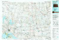
1993 Map of Devils Lake
USGS Topo · Published 1994About this map
Devils Lake and its intricate shoreline dominate the southwestern quadrant of this regional study, where the Devils Lake Sioux Indian Reservation and Gilbert C Grafton State Military Reservation anchor the landscape. The map reveals a transition between the deep water of Main Bay and the vast network of National Waterfowl Production Areas that define the prairie pothole region to the north. Transportation patterns are clearly delineated by the Burlington Northern and Soo Line railroads, which connected grain-handling settlements like Lakota, Michigan, and Starkweather during the late twentieth century.
Find a feature on this map
122 named features on this map. Tap any name to fly to it.
Don’t see what you’re looking for? This feature index may not catch every label — zoom into the map to look around manually.
Map Details
Editions of this 1993 Devils Lake Map
This is the sole edition of this map. No revisions or reprints were ever made.
Other maps of this area

1928 · Tokio
USGS Topo · 1:62,500

1930 · Pekin
USGS Topo · 1:62,500

1930 · Hamar
USGS Topo · 1:62,500

1931 · Oberon
USGS Topo · 1:62,500

1931 · Tokio
USGS Topo · 1:62,500

1931 · Devils Lake
USGS Topo · 1:62,500

1932 · Grahams Island
USGS Topo · 1:62,500

1939 · Niagara
USGS Topo · 1:62,500

1942 · McVille
USGS Topo · 1:62,500

1950 · Tokio
USGS Topo · 1:24,000