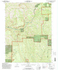
1995 Map of Devils Parade Ground
USGS Topo · Published 1998About this map
Devils Parade Ground provides a detailed look at the complex canyon and ridge systems of the western Sierra Nevada foothills during the mid-1990s. The landscape is defined by dramatic elevation changes between Cohasset Ridge and the deep incisions of Deer Creek and Big Chico Creek. The small settlement of Campbellville sits perched on the southwestern high ground, serving as a rare point of human habitation in a region otherwise dominated by protected lands. The transition from Lassen National Forest into the Ishi Wilderness and the State Game Refuge 1-G indicates a prioritisation of habitat preservation and remote recreation. Notable landmarks like Devils Kitchen and Pinnacle Peak punctuating the topography, alongside numerous water sources such as Polk Springs and Bennett Spring, suggest a terrain shaped by volcanic history and seasonal hydrology.
Find a feature on this map
37 named features on this map. Tap any name to fly to it.
Don’t see what you’re looking for? This feature index may not catch every label — zoom into the map to look around manually.
Map Details
Editions of this 1995 Devils Parade Ground Map
This is the sole edition of this map. No revisions or reprints were ever made.
Other maps of this area

1886 · Lassen Peak
USGS Topo · 1:250,000

1891 · Chico
USGS Topo · 1:125,000

1892 · Lassen Peak
USGS Topo · 1:250,000

1893 · Chico
USGS Topo · 1:125,000

1894 · Lassen Peak
USGS Topo · 1:250,000

1895 · Chico
USGS Topo · 1:125,000

1935 · Paynes Creek
USGS Topo · 1:96,000

1941 · Mineral
USGS Topo · 1:125,000

1944 · Richardson Springs
USGS Topo · 1:62,500
1952 · Campbell Mound
USGS Topo · 1:24,000