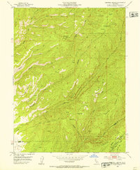
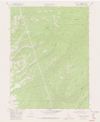
1952 Map of Campbell Mound
USGS Topo · Published 1953About this map
Lassen National Forest terrain dominates this 1952 study, where the Tehama and Butte County line crosses a landscape of deep canyons and prominent ridges. Named for the high ground at Campbell Mound, the area is defined by its water systems, including Deer Creek and the Keefer Creek drainage. Human activity in this remote territory is traced through primitive infrastructure such as the Campbellville Trail and various unnamed jeep trails that navigate the steep breaks of Barn Hollow and Nigger Gulch. Isolated outposts like Baccala Cabin and Franks Cabin provide a record of early timber or ranching life near Burroughs Pinery. The map also captures the northern edge of Cohasset and the notable landforms of Steamboat Point and Sugarloaf Mountain, documenting a transition between the volcanic foothills and the higher timberlands.
Find a feature on this map
32 named features on this map. Tap any name to fly to it.
Don’t see what you’re looking for? This feature index may not catch every label — zoom into the map to look around manually.
Map Details
Editions of this 1952 Campbell Mound Map
5 editions found
Other maps of this area

1886 · Lassen Peak
USGS Topo · 1:250,000

1891 · Chico
USGS Topo · 1:125,000

1892 · Lassen Peak
USGS Topo · 1:250,000

1893 · Chico
USGS Topo · 1:125,000

1894 · Lassen Peak
USGS Topo · 1:250,000

1895 · Chico
USGS Topo · 1:125,000

1912 · Nord
USGS Topo · 1:31,680

1912 · Keefers
USGS Topo · 1:31,680

1912 · Singer Creek
USGS Topo · 1:31,680

1935 · Paynes Creek
USGS Topo · 1:96,000