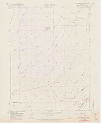
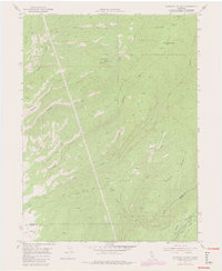
1952 Map of Campbell Mound
USGS Topo · Published 1970About this map
Lassen National Forest terrain dominates this landscape along the border of Tehama and Butte counties, where the high ground of Campbell Mound and Sugarloaf Ridge defines the drainage patterns of the northern Sacramento Valley foothills. The 1952 field-checked data reveals a network of primitive pack trails and jeep tracks connecting remote outposts such as Baccala Cabin and Franks Cabin. Water sources are vital landmarks in this environment, with named locations like Negro Spring, Root Spring, and Bell Spring providing essential waypoints for travelers and livestock. Downward toward the southern boundary, the topography transitions toward more defined watercourses like Keefer Slough and the Cohasset Branch, illustrating the transition from the timbered heights of Burroughs Pinery to the complex canyon systems of Deer Creek and Pine Creek.
Find a feature on this map
40 named features on this map. Tap any name to fly to it.
Don’t see what you’re looking for? This feature index may not catch every label — zoom into the map to look around manually.
Map Details
Editions of this 1952 Campbell Mound Map
5 editions found
Other maps of this area

1886 · Lassen Peak
USGS Topo · 1:250,000

1891 · Chico
USGS Topo · 1:125,000

1892 · Lassen Peak
USGS Topo · 1:250,000

1893 · Chico
USGS Topo · 1:125,000

1894 · Lassen Peak
USGS Topo · 1:250,000

1895 · Chico
USGS Topo · 1:125,000

1912 · Nord
USGS Topo · 1:31,680

1912 · Keefers
USGS Topo · 1:31,680

1912 · Singer Creek
USGS Topo · 1:31,680

1935 · Paynes Creek
USGS Topo · 1:96,000