
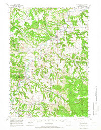
1955 Map of Devils Tower
USGS Topo · Published 1957About this map
Devils Tower National Monument dominates the western portion of this mid-century survey, surrounded by the winding loops of the Belle Fourche River. This map captures a landscape defined by ranching and rural education, where family operations like Devils Tower Ranch and the Fort Ranch are connected by a network of small schoolhouses. In the mid-1950s, the community of Hulett served as the local hub, complete with its own Rodeo Grounds and Hulett Sch. The mapping detail reflects a transition from traditional livestock territory toward recreational use, as seen in the proximity of Devils Tower PO to the monument. Numerous one-room schoolhouses, such as Wilson Sch, Cotton Sch, and Tower Divide Sch, are scattered throughout the Black Hills National Forest and along the various divides, illustrating the decentralized settlement pattern before the consolidation of rural schools.
Find a feature on this map
51 named features on this map. Tap any name to fly to it.
Don’t see what you’re looking for? This feature index may not catch every label — zoom into the map to look around manually.
Map Details
Editions of this 1955 Devils Tower Map
2 editions found
Other maps of this area

1898 · Sundance
USGS Topo · 1:125,000

1901 · Aladdin
USGS Topo · 1:125,000

1902 · Sundance
USGS Topo · 1:125,000

1903 · Aladdin
USGS Topo · 1:125,000

1905 · Devils Tower
USGS Topo · 1:125,000

1918 · Moorcroft
USGS Topo · 1:125,000

1918 · Moorcroft
USGS Topo · 1:62,500

1954 · Sunny Divide
USGS Topo · 1:24,000

1954 · Strawberry Hill
USGS Topo · 1:24,000

1954 · Storm Hill
USGS Topo · 1:24,000