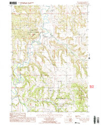
1984 Map of Devils Tower
USGS Topo · Published 1985About this map
Devils Tower National Monument anchors this 1980s survey, capturing the geological landmark and its surrounding river valley in Crook County. The Belle Fourche River winds through the western half of the map, creating a distinct riparian corridor against the elevated terrain of the Black Hills National Forest. Settlement is concentrated near the base of the monument, where a Post Office and campground serve as the hub for the area. The landscape is defined by its drainage systems, including Cempstool Draw and Miller Creek, which feed into the Belle Fourche. Small-scale rural features like a Cem near the eastern hills and a Gravel Pit to the north provide specific points of interest for local historians, while the community of Lytle sits along the road network leading away from the river valley.
Find a feature on this map
21 named features on this map. Tap any name to fly to it.
Don’t see what you’re looking for? This feature index may not catch every label — zoom into the map to look around manually.
Map Details
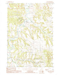
Editions of this 1984 Devils Tower Map
2 editions found
Other maps of this area

1905 · Devils Tower
USGS Topo · 1:125,000

1918 · Moorcroft
USGS Topo · 1:125,000

1918 · Moorcroft
USGS Topo · 1:62,500

1954 · Sunny Divide
USGS Topo · 1:24,000

1954 · Storm Hill
USGS Topo · 1:24,000

1954 · Carlile
USGS Topo · 1:24,000

1954 · Missouri Buttes
USGS Topo · 1:24,000

1954 · Gillette
USGS Topo · 1:250,000

1955 · Devils Tower
USGS Topo · 1:62,500

1955 · Gillette
USGS Topo · 1:250,000