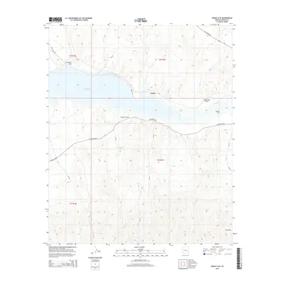
2014 Map of Dewey Flat
USGS Topo · Published 2014About this map
San Carlos Reservoir dominates the northern half of this landscape, its waters meeting the western flow of the Gila River. The settlement of Natches sits along the northern shore, while the eponymous Dewey Flat occupies the river terrace to the east. The terrain is defined by a series of deep drainages, including Hackberry Draw and Sycamore Gulch, which cut through the arid uplands south of the water. Infrastructure in this Graham County region is concentrated around Coolidge Dam Rd and various Bureau of Indian Affairs routes like Bia-555. Small water sources such as Sherman Spring are critical markers in this environment, illustrating the sparse but vital locations of surface water away from the primary river system.
Find a feature on this map
24 named features on this map. Tap any name to fly to it.
Don’t see what you’re looking for? This feature index may not catch every label — zoom into the map to look around manually.
Map Details
Editions of this 2014 Dewey Flat Map
This is the sole edition of this map. No revisions or reprints were ever made.
Other maps of this area

1954 · Mesa
USGS Topo · 1:250,000

1957 · Mesa
USGS Topo · 1:250,000

1958 · Mesa
USGS Topo · 1:250,000

1960 · Mesa
USGS Topo · 1:250,000

1960 · Bylas
USGS Topo · 1:62,500

1962 · San Carlos Reservoir
USGS Topo · 1:62,500

1964 · Mesa
USGS Topo · 1:250,000

1966 · Branaman Spring
USGS Topo · 1:24,000
1966 · Mount Triplet
USGS Topo · 1:24,000
1966 · San Carlos
USGS Topo · 1:24,000