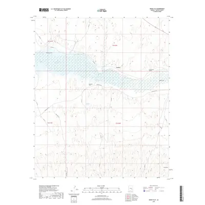
2018 Map of Dewey Flat
USGS Topo · Published 2018About this map
San Carlos Reservoir dominates the northern landscape of this Graham County region, where the Gila River enters from the east near the eponymous Dewey Flat. The settlement of Natches sits on the northern shore of the reservoir, positioned along the historical corridor defined by Coolidge Dam Rd. This 2018 survey illustrates a complex desert hydrology where seasonal drainages like Salt Cr and Hackberry Draw feed into the reservoir's basin. To the south, the terrain becomes increasingly intricate as it rises away from the river, marked by local water sources such as Sherman Spring and deep cuts like Sycamore Gulch and Cottonwood Canyon. The map provides a modern look at the rural infrastructure in the San Carlos Apache Indian Reservation vicinity, detailing numerous local routes including Co Rd 400 and House Road 550 that navigate the high-relief desert landscape.
Find a feature on this map
26 named features on this map. Tap any name to fly to it.
Don’t see what you’re looking for? This feature index may not catch every label — zoom into the map to look around manually.
Map Details
Editions of this 2018 Dewey Flat Map
This is the sole edition of this map. No revisions or reprints were ever made.
Other maps of this area

1954 · Mesa
USGS Topo · 1:250,000

1957 · Mesa
USGS Topo · 1:250,000

1958 · Mesa
USGS Topo · 1:250,000

1960 · Mesa
USGS Topo · 1:250,000

1960 · Bylas
USGS Topo · 1:62,500

1962 · San Carlos Reservoir
USGS Topo · 1:62,500

1964 · Mesa
USGS Topo · 1:250,000

1966 · Branaman Spring
USGS Topo · 1:24,000
1966 · Mount Triplet
USGS Topo · 1:24,000
1966 · San Carlos
USGS Topo · 1:24,000