
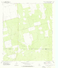
1965 Map of Dewey Lake SE
USGS Topo · Published 1966About this map
Lacy Creek and a network of ephemeral watercourses like the Draw define this Glasscock County landscape in the mid-1960s. The region is marked by its transition from ranching infrastructure to industrial development, featuring multiple Gravel Pits and an extensive Pipeline network. Named landmarks such as Morgan Windmill and Schoolhouse Windmill provide specific touchpoints for local family history, reflecting the essential water-scavenging infrastructure of the Texas high plains. Transportation is centered on Route 158, where a Roadside Park and an electrical Substation reflect the modernization of the rural corridor. This survey was conducted just as aerial photogrammetric methods and planetable surveys were coming together to provide high-resolution topographic data for this cattle and energy-producing area.
Find a feature on this map
10 named features on this map. Tap any name to fly to it.
Don’t see what you’re looking for? This feature index may not catch every label — zoom into the map to look around manually.
Map Details
Editions of this 1965 Dewey Lake SE Map
This is the sole edition of this map. No revisions or reprints were ever made.
Other maps of this area

1954 · San Angelo
USGS Topo · 1:250,000

1958 · San Angelo
USGS Topo · 1:250,000

1963 · Ballinger Ranch
USGS Topo · 1:24,000

1963 · Garden City
USGS Topo · 1:24,000

1964 · Dewey Lake NE
USGS Topo · 1:24,000

1965 · San Angelo
USGS Topo · 1:250,000

1965 · Dewey Lake
USGS Topo · 1:24,000

1965 · Patterson Lake
USGS Topo · 1:24,000

1973 · Bigby Corner
USGS Topo · 1:24,000
1973 · Three Bluff Draw NW
USGS Topo · 1:24,000