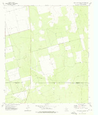
1973 Map of Three Bluff Draw NW
USGS Topo · Published 1976About this map
The West Texas landscape along the Glasscock Co and Reagan Co line is defined by a heavy industrial footprint in the early 1970s. This survey records a high density of Oil Wells and a significant Pipeline network, reflecting the area's role in the Permian Basin's energy production. The terrain is characterized by a mix of natural draws and artificial excavations, such as a local Gravel Pit, interspersed with hundreds of Wells that suggest both agricultural and industrial water management. The mapping of numerous Oil Wells during this era provides a clear view of the subsurface resources being tapped and the surface infrastructure required to transport petroleum across this part of the state.
Find a feature on this map
7 named features on this map. Tap any name to fly to it.
Don’t see what you’re looking for? This feature index may not catch every label — zoom into the map to look around manually.
Map Details
Editions of this 1973 Three Bluff Draw NW Map
This is the sole edition of this map. No revisions or reprints were ever made.
Other maps of this area

1954 · San Angelo
USGS Topo · 1:250,000

1958 · San Angelo
USGS Topo · 1:250,000

1963 · Currie Reservoir
USGS Topo · 1:24,000

1963 · Garden City
USGS Topo · 1:24,000

1965 · San Angelo
USGS Topo · 1:250,000

1965 · Dewey Lake SE
USGS Topo · 1:24,000

1973 · Three Bluff Draw
USGS Topo · 1:24,000

1973 · Three Bluff Draw NE
USGS Topo · 1:24,000

1973 · Saint Lawrence SE
USGS Topo · 1:24,000
1973 · Three Bluff Draw SW
USGS Topo · 1:24,000