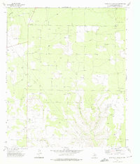
1973 Map of Three Bluff Draw SW
USGS Topo · Published 1976About this map
The West Texas ranchlands of Reagan County are defined here by a pervasive energy and extraction economy. In the early 1970s, the landscape is heavily marked by a dense network of Oil Wells and Drill Holes, connected by miles of pipelines and service tracks. This industrial overlay rests upon a terrain carved by ephemeral watercourses, primarily the North Creek Draw and its West Fork. Amidst the widespread petroleum infrastructure, the Reagan View Cemetery serves as a lone quiet landmark, situated near several Gravel Pits and a prominent Radio Tower. The survey illustrates the functional, working character of the High Plains during a peak era of domestic oil production, where traditional land use and modern resource extraction coexist.
Find a feature on this map
8 named features on this map. Tap any name to fly to it.
Don’t see what you’re looking for? This feature index may not catch every label — zoom into the map to look around manually.
Map Details
Editions of this 1973 Three Bluff Draw SW Map
This is the sole edition of this map. No revisions or reprints were ever made.
Other maps of this area

1928 · Rankin
USGS Topo · 1:125,000

1954 · San Angelo
USGS Topo · 1:250,000

1958 · San Angelo
USGS Topo · 1:250,000

1965 · San Angelo
USGS Topo · 1:250,000

1970 · South Mustang Draw NE
USGS Topo · 1:24,000

1970 · Moore Hill
USGS Topo · 1:24,000

1970 · Stiles
USGS Topo · 1:24,000

1973 · Three Bluff Draw
USGS Topo · 1:24,000

1973 · Three Bluff Draw NE
USGS Topo · 1:24,000

1973 · Saint Lawrence SE
USGS Topo · 1:24,000