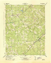
1944 Map of DeWitt
USGS Topo · Published 1944About this map
The Seaboard railroad corridor anchors the rural landscape of Dinwiddie County during the mid-1940s, connecting the adjacent settlements of DeWitt and Butterworth. This area is characterized by a dense network of country churches that served as the social fabric for local farming families, including Bott Memorial Church, Mt Calvary Church, and the isolated Eleven Oak Church. Small commercial hubs such as Wilkinsons Store and crossroads like Baltimore Corner or Center Star provided essential services before the era of widespread automobile travel. The terrain is deeply etched by a complex drainage system featuring Butterwood Creek, Stony Creek, and Sapony Creek, which historically supported industry at sites like Hills Mill. Military and navigation efforts of the era are visible through specialized markers like the USC&GS Beacon 1942 and the USC&GS Lo Tower 1942, reflecting the geographic importance of this region south of the state capital during the war years.
Find a feature on this map
27 named features on this map. Tap any name to fly to it.
Don’t see what you’re looking for? This feature index may not catch every label — zoom into the map to look around manually.
Map Details
Editions of this 1944 DeWitt Map
This is the sole edition of this map. No revisions or reprints were ever made.
Other maps of this area

1897 · Amelia
USGS Topo · 1:125,000

1918 · Lawrenceville
USGS Topo · 1:62,500

1919 · Mc Kenney
USGS Topo · 1:48,000

1920 · Lawrenceville
USGS Topo · 1:48,000

1921 · Mc Kenney
USGS Topo · 1:62,500

1921 · Lawrenceville
USGS Topo · 1:62,500

1942 · Lawrenceville
USGS Topo · 1:62,500

1943 · Mc Kenney
USGS Topo · 1:62,500

1943 · De Witt
USGS Topo · 1:24,000
1943 · Dinwiddie
USGS Topo · 1:24,000