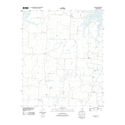
2010 Map of Dexter
USGS Topo · Published 2010About this map
Dexter and the rural communities of northern Grayson County sit along the southern reaches of the Red River, where the landscape is defined by the winding tributaries flowing toward Lake Texoma. This 2010 survey illustrates the transition from traditional river-valley settlement to a modern landscape marked by water management and energy extraction. Long-established family and community ties are evident in the numerous burial grounds scattered across the terrain, including Mount Zion Cemetery near the river bluffs and Shiloh Cemetery further inland. The legacy of the river as a crossing point is preserved by the label for Stillhouse Ferry, while the interior shows the footprint of the Ranbalm Oil Field. Small water bodies like Collums Lake and Williams Lake dot the countryside, connected by a network of secondary roads such as Delaware Bend Rd and Sycamore Creek Rd, serving the small hamlets of Red Branch and Sandusky.
Find a feature on this map
72 named features on this map. Tap any name to fly to it.
Don’t see what you’re looking for? This feature index may not catch every label — zoom into the map to look around manually.
Map Details
Editions of this 2010 Dexter Map
This is the sole edition of this map. No revisions or reprints were ever made.
Other maps of this area

1901 · Denison
USGS Topo · 1:125,000

1902 · Gainesville
USGS Topo · 1:125,000

1943 · Gainesville
USGS Topo · 1:125,000

1954 · Sherman
USGS Topo · 1:250,000

1958 · Gordonville
USGS Topo · 1:62,500

1958 · Whitesboro
USGS Topo · 1:62,500

1958 · Sherman
USGS Topo · 1:250,000

1960 · Callisburg
USGS Topo · 1:24,000
1967 · Marietta East
USGS Topo · 1:24,000
1968 · Horseshoe Bend
USGS Topo · 1:24,000