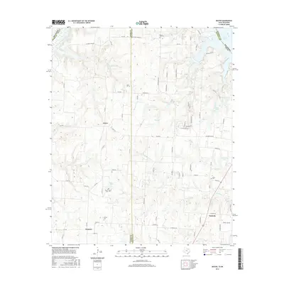
2016 Map of Dexter
USGS Topo · Published 2016About this map
The Red River defines the northern boundary of this Texas landscape, where the waters of Lake Texoma reach into the creek-carved hills of Grayson and Cooke Counties. This territory is marked by small rural nodes such as Dexter, Sandusky, and Sturgeon, linked by a network of county roads and farm-to-market routes. The terrain is deeply dissected by numerous watercourses, including Sycamore Cr, Rock Cr, and Red Br, which flow toward the primary river valley.
Find a feature on this map
89 named features on this map. Tap any name to fly to it.
Don’t see what you’re looking for? This feature index may not catch every label — zoom into the map to look around manually.
Map Details
Editions of this 2016 Dexter Map
This is the sole edition of this map. No revisions or reprints were ever made.
Other maps of this area

1901 · Denison
USGS Topo · 1:125,000

1902 · Gainesville
USGS Topo · 1:125,000

1943 · Gainesville
USGS Topo · 1:125,000

1954 · Sherman
USGS Topo · 1:250,000

1958 · Gordonville
USGS Topo · 1:62,500

1958 · Whitesboro
USGS Topo · 1:62,500

1958 · Sherman
USGS Topo · 1:250,000

1960 · Callisburg
USGS Topo · 1:24,000
1967 · Marietta East
USGS Topo · 1:24,000
1968 · Horseshoe Bend
USGS Topo · 1:24,000