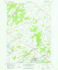
1958 Map of Dexter
USGS Topo · Published 1976About this map
Dexter and Limerick sit at the crossroads of water-driven industry and agricultural trade in this late-1950s survey of Jefferson County. The Black River dominates the southern landscape, flowing into Black River Bay while providing power for the settlement at Dexter, which features a dense grid of streets, the Dexter Cemetery, and a riverside Pumping Sta. Further north, the Perch River meanders through broad flats, passing the Brownville State Game Farm and the village of Perch River. The transition from rail to road is evident here, as the New York Central Railroad corridor parallels an Old Railroad Grade, reflecting the changing transportation needs of these riverfront communities. Notable local landmarks like the General Brown High Sch and the geological curiosity of Natural Bridge provide specific points of interest for local historians and genealogists researching the Brownville and Lyme areas.
Find a feature on this map
48 named features on this map. Tap any name to fly to it.
Don’t see what you’re looking for? This feature index may not catch every label — zoom into the map to look around manually.
Map Details
Editions of this 1958 Dexter Map
3 editions found
Other maps of this area

1893 · Sackets Harbor
USGS Topo · 1:62,500

1895 · Sacketts Harbor
USGS Topo · 1:62,500

1895 · Watertown
USGS Topo · 1:62,500

1898 · Watertown
USGS Topo · 1:62,500

1900 · Clayton
USGS Topo · 1:62,500

1903 · Clayton
USGS Topo · 1:62,500

1903 · Theresa
USGS Topo · 1:62,500

1908 · Watertown
USGS Topo · 1:62,500

1909 · Watertown
USGS Topo · 1:62,500

1942 · Henderson Bay
USGS Topo · 1:31,680