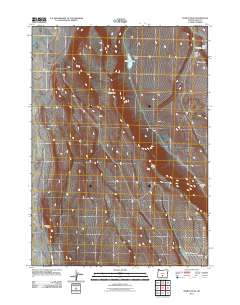
2011 Map of Diablo Peak
USGS Topo · Published 2011About this map
Diablo Peak stands as the central topographic feature in this high desert landscape of Lake County, where the dramatic volcanic geology of the Great Basin is on full display. The area is defined by sharp escarpments and interior drainages, most notably the prominent Diablo Rim that cuts through the central and southern sections. Water is a scarce and precious resource in this environment, represented here by scattered seasonal catchments such as Murphys Lake, West Whiskey Lake, and the man-made Slim Reservoir. These water sources, along with the Whiskey Hills and landmarks like Jackings Hole, point to the region's history of range management and livestock grazing. Transportation is limited to the periphery, with E Summer Lake Rd providing the primary access along the western edge of this isolated terrain.
Find a feature on this map
9 named features on this map. Tap any name to fly to it.
Don’t see what you’re looking for? This feature index may not catch every label — zoom into the map to look around manually.
Map Details
Editions of this 2011 Diablo Peak Map
This is the sole edition of this map. No revisions or reprints were ever made.
Other maps of this area

1955 · Crescent
USGS Topo · 1:250,000

1955 · Klamath Falls
USGS Topo · 1:250,000

1957 · Crescent
USGS Topo · 1:250,000

1958 · Crescent
USGS Topo · 1:250,000

1958 · Klamath Falls
USGS Topo · 1:250,000

1970 · Crescent
USGS Topo · 1:250,000

1974 · Lake Abert
USGS Topo · 1:100,000

1985 · Sharp Top
USGS Topo · 1:24,000

1986 · St. Patrick Mtn.
USGS Topo · 1:24,000
1986 · Ana River
USGS Topo · 1:24,000