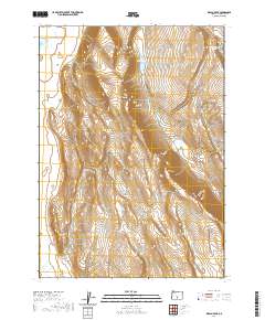
2020 Map of Diablo Peak
USGS Topo · Published 2020About this map
Diablo Peak rises as the central landmark in this high-desert landscape of Lake County, as documented by the U.S. Geological Survey in 2020. The topography is defined by the dramatic escarpment of the Diablo Rim, which overlooks a series of remote basins and seasonal water features. To the northeast, the Whiskey Hills and West Whiskey Lake reflect a history of colorful local place-naming, while features like Jackings Hole and Fourmile Point suggest the area's importance for early navigation and land use in the Oregon outback. Human modification of the arid environment is evident in the presence of Brief Reservoir and Slim Reservoir, while Murphy's Lake remains a notable natural hydrologic feature. The map maintains the Public Land Survey System grid, including townships t30s r18e and t31s r19e, which continue to define the boundaries of these isolated ranges.
Find a feature on this map
13 named features on this map. Tap any name to fly to it.
Don’t see what you’re looking for? This feature index may not catch every label — zoom into the map to look around manually.
Map Details
Editions of this 2020 Diablo Peak Map
This is the sole edition of this map. No revisions or reprints were ever made.
Other maps of this area

1955 · Crescent
USGS Topo · 1:250,000

1955 · Klamath Falls
USGS Topo · 1:250,000

1957 · Crescent
USGS Topo · 1:250,000

1958 · Crescent
USGS Topo · 1:250,000

1958 · Klamath Falls
USGS Topo · 1:250,000

1970 · Crescent
USGS Topo · 1:250,000

1974 · Lake Abert
USGS Topo · 1:100,000

1985 · Sharp Top
USGS Topo · 1:24,000

1986 · St. Patrick Mtn.
USGS Topo · 1:24,000
1986 · Ana River
USGS Topo · 1:24,000