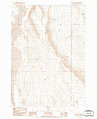
1986 Map of Diablo Peak
USGS Topo · Published 1986About this map
Diablo Peak dominates this high-desert landscape in Lake County, where the dramatic Diablo Rim forms a sharp geological boundary against the expanse of Diablo Flat. This 1986 survey documents a region defined by its water scarcity and ranching infrastructure, characterized by scattered water sources like Banta Well, Devil Well, and the Flowing Well. The mapping of small, named catchments such as Brief Reservoir and Slim Reservoir underscores the vital importance of water management in this arid environment.
Find a feature on this map
18 named features on this map. Tap any name to fly to it.
Don’t see what you’re looking for? This feature index may not catch every label — zoom into the map to look around manually.
Map Details
Editions of this 1986 Diablo Peak Map
This is the sole edition of this map. No revisions or reprints were ever made.
Other maps of this area

1955 · Crescent
USGS Topo · 1:250,000

1955 · Klamath Falls
USGS Topo · 1:250,000

1957 · Crescent
USGS Topo · 1:250,000

1958 · Crescent
USGS Topo · 1:250,000

1958 · Klamath Falls
USGS Topo · 1:250,000

1970 · Crescent
USGS Topo · 1:250,000

1974 · Lake Abert
USGS Topo · 1:100,000

1985 · Sharp Top
USGS Topo · 1:24,000

1986 · St. Patrick Mtn.
USGS Topo · 1:24,000
1986 · Ana River
USGS Topo · 1:24,000