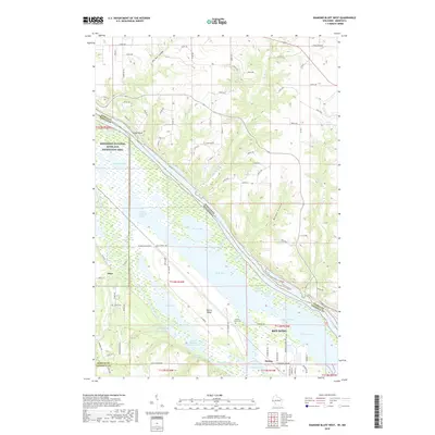
2018 Map of Diamond Bluff West
USGS Topo · Published 2018About this map
The Mississippi River and its complex network of sloughs and backwaters dominate this landscape at the confluence of the river and the Vermillion River. The presence of the Prairie Island Cem and the settlement of Prairie Island reflect the area's deep indigenous and early pioneer roots. Large water bodies such as North Lake, Sturgeon Lake, and Mud Hen Lake illustrate the transition from upland coulees to the river's floodplain. In the northern reaches, the terrain is characterized by deep ravines like Dry Run Coulee and Morgan Coulee, which drain toward the valley. The settlement of Red Wing appears at the southeastern edge, while smaller locales like Etter and Stroms anchor the western and southern boundaries. This survey documents the preserved environmental corridors within the Mississippi National River and Recreation Area.
Find a feature on this map
105 named features on this map. Tap any name to fly to it.
Don’t see what you’re looking for? This feature index may not catch every label — zoom into the map to look around manually.
Map Details
Editions of this 2018 Diamond Bluff West Map
This is the sole edition of this map. No revisions or reprints were ever made.
Other maps of this area

1944 · Red Wing
USGS Topo · 1:62,500

1946 · Hudson
USGS Topo · 1:62,500

1946 · River Falls
USGS Topo · 1:62,500

1949 · River Falls
USGS Topo · 1:62,500

1949 · Hudson
USGS Topo · 1:62,500

1951 · Prescott
USGS Topo · 1:24,000

1952 · Red Wing
USGS Topo · 1:62,500

1953 · Saint Paul
USGS Topo · 1:250,000

1957 · Hastings
USGS Topo · 1:62,500

1959 · Saint Paul
USGS Topo · 1:250,000