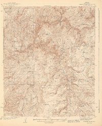
1943 Map of Diamond Butte
USGS Topo · Published 1943About this map
The Tonto National Forest dominates this mid-century survey of the Gila County high country, revealing a landscape defined by isolated ranches and rugged mountain peaks. Settlement is sparse, characterized by individual outposts such as Vaughn Ranch, Lazear Ranch, and the Old Rock House in the northwest. The drainage of Tonto Creek and its many tributaries, including Walnut Creek and Pigeon Creek Canyon, carve deep through the terrain near landmarks like Diamond Butte and McDonald Mtn. Local history is preserved in the names of remote dwellings and camps, from the Fred Pranty Cabin to the Flying W Ranch. This topography reflects the early 20th-century cattle and ranching economy of central Arizona before modern infrastructure reached these canyons, as seen in the proximity of names like Robbers Roost Mtn and Buzzard Roost Camp.
Find a feature on this map
55 named features on this map. Tap any name to fly to it.
Don’t see what you’re looking for? This feature index may not catch every label — zoom into the map to look around manually.
Map Details
Editions of this 1943 Diamond Butte Map
2 editions found

Other maps of this area

1886 · Holbrook
USGS Topo · 1:250,000

1887 · Verde
USGS Topo · 1:250,000

1892 · Verde
USGS Topo · 1:250,000

1893 · Holbrook
USGS Topo · 1:250,000

1907 · Roosevelt
USGS Topo · 1:125,000

1909 · Four Peaks
USGS Topo · 1:125,000

1912 · Roosevelt
USGS Topo · 1:125,000

1922 · Chrysotile
USGS Topo · 1:125,000

1934 · Pine
USGS Topo · 1:62,500

1934 · Promontory Butte
USGS Topo · 1:62,500