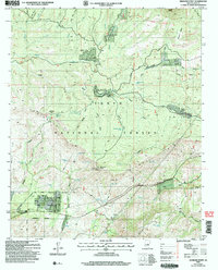
2004 Map of Diamond Point
USGS Topo · Published 2006About this map
Tonto National Forest land dominates this 2004 revision, where residential pockets like Tonto Village and Diamond Point Shadows meet the edge of the Star Valley Corporate Boundary. The map illustrates a landscape of high mesas and deep drainage draws, punctuated by summer home developments such as Ellison Creek Estates and Diamond Point Summer Homes. This area, managed in part by the Forest Service, is defined by its recreation and utility infrastructure, from the Highline National Recreation Trail winding across the northern ridges to the Control Site Lookout Tower at Diamond Point. Local water sources are vital to this dry environment, documented through numerous features like Oak Spring Draw Tank and Gilliland Spring. The southern portion of the quadrangle shows the operational presence of the Gila County Yard and various substations, reflecting the area's service to the nearby growing communities of Gila County.
Find a feature on this map
72 named features on this map. Tap any name to fly to it.
Don’t see what you’re looking for? This feature index may not catch every label — zoom into the map to look around manually.
Map Details
Editions of this 2004 Diamond Point Map
This is the sole edition of this map. No revisions or reprints were ever made.
Other maps of this area

1887 · Verde
USGS Topo · 1:250,000

1892 · Verde
USGS Topo · 1:250,000

1934 · Pine
USGS Topo · 1:62,500

1934 · Promontory Butte
USGS Topo · 1:62,500

1936 · Payson
USGS Topo · 1:48,000

1937 · Diamond Butte
USGS Topo · 1:48,000

1939 · Promontory Butte
USGS Topo · 1:62,500

1940 · Pine
USGS Topo · 1:62,500

1942 · Payson
USGS Topo · 1:62,500

1943 · Diamond Butte
USGS Topo · 1:62,500
Featured Places
- Star Valley, AZ
- Diamond Point Summer Homes, AZ
- Ellison Creek Summer Homes, AZ
- Little Green Valley, AZ
- Ellison Creek Estates, AZ