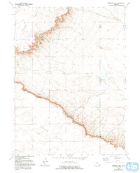
1963 Map of Dickinson Hill
USGS Topo · Published 1993About this map
Goshen Hole Rim defines the dramatic geological shift across this landscape, where the high-elevation Slater Flats drop away into the basin. This terrain is marked by essential water sources like Mud Springs and Forney Springs, which were critical for the early ranching operations that defined life on the Wyoming high plains. Evidence of mid-century infrastructure appears through a pipeline and a Pumping Sta, reflecting the modernization of resource management in a semi-arid environment. Local land use is further anchored by the Baker Ranch, situated near the head of Forney Draw. The inclusion of a Wind Charger on the map provides a specific mechanical detail of rural life, suggesting how early residents harnessed the persistent winds for power before widespread electrification reached these distant parcels.
Find a feature on this map
14 named features on this map. Tap any name to fly to it.
Don’t see what you’re looking for? This feature index may not catch every label — zoom into the map to look around manually.
Map Details
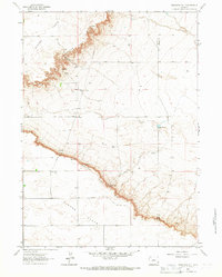
Editions of this 1963 Dickinson Hill Map
2 editions found
Other maps of this area

1896 · Hartville
USGS Topo · 1:125,000

1901 · Hartville
USGS Topo · 1:125,000

1950 · Rockeagle
USGS Topo · 1:24,000

1951 · Antelope Gap
USGS Topo · 1:24,000

1951 · Eagles Nest
USGS Topo · 1:24,000

1953 · Chugwater
USGS Topo · 1:24,000

1953 · Bordeaux
USGS Topo · 1:24,000

1954 · Torrington
USGS Topo · 1:250,000

1954 · Cheyenne
USGS Topo · 1:250,000

1958 · Cheyenne
USGS Topo · 1:250,000