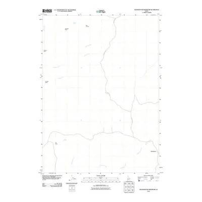
2010 Map of Dickshooter Reservoir
USGS Topo · Published 2010About this map
Antelope Basin and Cowboy Basin define the high desert character of this Owyhee County landscape as it appeared in 2010. The namesake settlement of Dickshooter sits at the intersection of a local track and Dickshooter Creek in the southeastern portion of the quadrangle. This area is characterized by scattered water sources essential for livestock and wildlife, including Antelope Spring and Albert Spring. The drainage network is anchored by Lightning Creek and Cowboy Creek, while notable elevations like Flatiron Butte and Big Point provide landmarks across the open terrain. Human movement through the region is primary channeled along the winding Dickshooter Rd, connecting the isolated settlement to the wider basin. The map illustrates a high-plateau environment where natural landforms such as Box Canyon dominate the topography.
Find a feature on this map
13 named features on this map. Tap any name to fly to it.
Don’t see what you’re looking for? This feature index may not catch every label — zoom into the map to look around manually.
Map Details
Editions of this 2010 Dickshooter Reservoir Map
This is the sole edition of this map. No revisions or reprints were ever made.
Other maps of this area

1955 · Jordan Valley
USGS Topo · 1:250,000

1957 · Jordan Valley
USGS Topo · 1:250,000

1958 · Jordan Valley
USGS Topo · 1:250,000
1972 · Frying Pan Basin
USGS Topo · 1:24,000
1972 · Big Springs Ranch
USGS Topo · 1:24,000
1972 · Battle Creek Lakes
USGS Topo · 1:24,000
1973 · Wagon Box Basin
USGS Topo · 1:24,000

1973 · Castro Table
USGS Topo · 1:24,000
1973 · Dickshooter Reservoir
USGS Topo · 1:24,000

1973 · Brace Flat
USGS Topo · 1:24,000