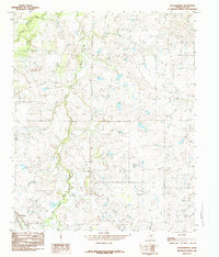
1984 Map of Dickworsham
USGS Topo · Published 1985About this map
Dickworsham sits in the southwestern corner of this Clay County landscape, where the winding course of the Little Wichita River dominates the terrain. The river is joined by the Dry Fork and East Fork, creating a network of riparian corridors through the Texas ranch land. A notable vestige of earlier transport infrastructure is the Old Railroad Grade that cuts across the northern half of the map, providing a clear path for historians and researchers to trace the legacy of defunct rail lines in the region.
Find a feature on this map
10 named features on this map. Tap any name to fly to it.
Don’t see what you’re looking for? This feature index may not catch every label — zoom into the map to look around manually.
Map Details
Editions of this 1984 Dickworsham Map
This is the sole edition of this map. No revisions or reprints were ever made.
Other maps of this area

1905 · Montague
USGS Topo · 1:125,000

1954 · Sherman
USGS Topo · 1:250,000

1954 · Wichita Falls
USGS Topo · 1:250,000

1956 · Henrietta
USGS Topo · 1:62,500

1958 · Wichita Falls
USGS Topo · 1:250,000

1958 · Sherman
USGS Topo · 1:250,000

1961 · Stoneburg
USGS Topo · 1:24,000
1968 · Bellevue
USGS Topo · 1:24,000
1968 · Terral
USGS Topo · 1:24,000
1968 · Bluegrove
USGS Topo · 1:24,000