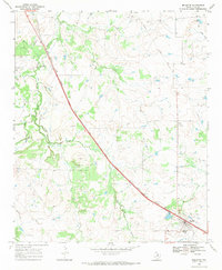
1968 Map of Bellevue
USGS Topo · Published 1971About this map
Bellevue serves as the primary hub on this North Texas prairie landscape, situated along the diagonal path of the Fort Worth and Denver railroad. The settlement's infrastructure in the late 1960s is anchored by a High Sch and an established town Cem, while a network of natural drainage including the Little Wichita River, Smith Creek, and Canyon Creek defines the local topography.
Find a feature on this map
17 named features on this map. Tap any name to fly to it.
Don’t see what you’re looking for? This feature index may not catch every label — zoom into the map to look around manually.
Map Details
Editions of this 1968 Bellevue Map
This is the sole edition of this map. No revisions or reprints were ever made.
Other maps of this area

1905 · Montague
USGS Topo · 1:125,000

1954 · Sherman
USGS Topo · 1:250,000

1954 · Wichita Falls
USGS Topo · 1:250,000

1956 · Henrietta
USGS Topo · 1:62,500

1958 · Wichita Falls
USGS Topo · 1:250,000

1958 · Sherman
USGS Topo · 1:250,000

1961 · Stoneburg
USGS Topo · 1:24,000

1961 · Brushy Mound
USGS Topo · 1:24,000
1963 · Vashti
USGS Topo · 1:24,000
1964 · Joy
USGS Topo · 1:24,000