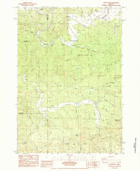
1984 Map of Digger Mtn
USGS Topo · Published 1984About this map
Alsea River winding through the western Cascades dominates this mid-1980s terrain, where the river's deep curves create distinct geographic points like Missouri Bend. This landscape is defined by the intersection of water and timber management, with much of the territory protected within the Siuslaw National Forest. Rural infrastructure is concentrated along the riverbanks and creek valleys, notably where Missouri Bend School and several boat landings, including Campbell Boat Landing and Salmonberry Boat Landing, suggest a community oriented toward the water. To the south, Lobster Valley provides a clear low-lying corridor between the heights of Little Lobster Summit and Taylor Butte. Researchers can find evidence of small-scale rural life at Lone Fir Cem and traces of local industry at the Quarry near Bear Creek.
Find a feature on this map
37 named features on this map. Tap any name to fly to it.
Don’t see what you’re looking for? This feature index may not catch every label — zoom into the map to look around manually.
Map Details
Editions of this 1984 Digger Mtn Map
This is the sole edition of this map. No revisions or reprints were ever made.
Other maps of this area

1918 · Mapleton
USGS Topo · 1:48,000

1940 · Mapleton
USGS Topo · 1:62,500

1941 · Blachly
USGS Topo · 1:62,500

1942 · Alsea
USGS Topo · 1:62,500

1942 · Blachly
USGS Topo · 1:62,500

1942 · Tidewater
USGS Topo · 1:62,500

1945 · Mapleton
USGS Topo · 1:62,500

1953 · Salem
USGS Topo · 1:250,000

1954 · Salem
USGS Topo · 1:250,000

1956 · Alsea
USGS Topo · 1:62,500