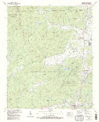
1988 Map of Dillard
USGS Topo · Published 1988About this map
Dillard and Mountain City serve as the primary valley settlements in this late-twentieth-century study of the northeast Georgia highlands. The terrain is defined by the Blue Ridge Divide, which separates the waters of the Little Tennessee River from the headwaters of Stekoa Creek. This geographic split is mirrored by the extensive protected lands of the Nantahala National Forest and Chattahoochee National Forest, which dominate the high ridges. Significant historical landmarks include the Dickerson Mill and the Queen Mine, alongside the expansive grounds of the Rabun Gap Nacoochee Sch. Cultural indicators of older rural communities are scattered throughout the valleys, from the Germany Cem and Mountain Grove Ch Cem to the mountain recreation sites at Black Rock Mountain State Park and Camp Barron.
Find a feature on this map
135 named features on this map. Tap any name to fly to it.
Don’t see what you’re looking for? This feature index may not catch every label — zoom into the map to look around manually.
Map Details
Editions of this 1988 Dillard Map
2 editions found
Other maps of this area

1886 · Dahlonega
USGS Topo · 1:125,000

1886 · Walhalla
USGS Topo · 1:125,000

1891 · Cowee
USGS Topo · 1:125,000

1892 · Dahlonega
USGS Topo · 1:125,000

1892 · Walhalla
USGS Topo · 1:125,000

1896 · Walhalla
USGS Topo · 1:125,000

1896 · Dahlonega
USGS Topo · 1:125,000

1897 · Cowee
USGS Topo · 1:125,000

1903 · Dahlonega
USGS Topo · 1:125,000

1907 · Cowee
USGS Topo · 1:125,000