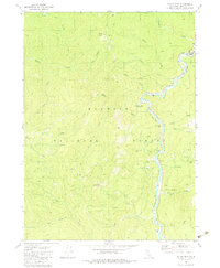
1983 Map of Dillon Mtn
USGS Topo · Published 1983About this map
The Klamath River carves a deep path through this portion of the Klamath National Forest, where steep terrain and narrow river bars defined the limits of human settlement. Along the river's winding course, early 1980s land use is marked by small pockets of activity such as the Ti Bar Forest Service Station and Dillon Creek Campground. The map records historical habitation at the Kennedy Homestead and the Cottage Grove (Site), suggesting a landscape where once-active homesteads and small sites were gradually reclaimed by the forest. The presence of a Cem and the curious Iron Phone marker near Kennedy Creek provides specific points of interest for local historians and genealogists tracing the sparse population of this mountainous region. Numerous river bars, including Rattlesnake Bar and Persido Bar, highlight the importance of the river corridor for access and seasonal occupation.
Find a feature on this map
44 named features on this map. Tap any name to fly to it.
Don’t see what you’re looking for? This feature index may not catch every label — zoom into the map to look around manually.
Map Details
Editions of this 1983 Dillon Mtn Map
2 editions found
Other maps of this area

1914 · Seiad
USGS Topo · 1:125,000

1922 · Preston Peak
USGS Topo · 1:125,000

1922 · Seiad
USGS Topo · 1:125,000

1925 · Hoopa
USGS Topo · 1:125,000

1948 · Weed
USGS Topo · 1:250,000

1950 · Weed
USGS Topo · 1:250,000

1952 · Orleans
USGS Topo · 1:62,500

1955 · Dillon Mtn
USGS Topo · 1:62,500

1955 · Ukonom Lake
USGS Topo · 1:62,500

1955 · Forks of Salmon
USGS Topo · 1:62,500