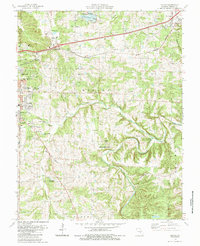
1985 Map of Dillon
USGS Topo · Published 1985About this map
Rolla expansion and the corridor toward St James define this mid-1980s landscape, where the Burlington Northern railroad and interstate highway cut across the Ozark Plateau. The map captures a high density of rural religious and commemorative sites, including New Life Ch, Bible Faith Assembly, and Bellview Ch, alongside numerous family burial grounds like Wilson Cem and Hawkins Cem. The terrain is deeply dissected by the Dry Fork and Little Dry Fork, creating a complex network of ridges like Schumann Ridge that hem in local aviation landmarks such as the Morgan Landing Strip. Recreation and modern infrastructure are visible through the Oak Meadow Country Club and the Little Prairie Community Lake, illustrating the transition from traditional farming and quarrying toward suburban development near the Missouri S&T campus area.
Find a feature on this map
56 named features on this map. Tap any name to fly to it.
Don’t see what you’re looking for? This feature index may not catch every label — zoom into the map to look around manually.
Map Details
Editions of this 1985 Dillon Map
This is the sole edition of this map. No revisions or reprints were ever made.
Other maps of this area

1912 · Rolla
USGS Topo · 1:62,500

1928 · Meramec Spring
USGS Topo · 1:62,500

1934 · Redbird
USGS Topo · 1:62,500

1937 · Vienna
USGS Topo · 1:62,500

1938 · Redbird
USGS Topo · 1:62,500

1938 · Vienna
USGS Topo · 1:48,000

1949 · Saint Louis
USGS Topo · 1:250,000

1949 · Vienna
USGS Topo · 1:62,500

1949 · Rolla
USGS Topo · 1:250,000

1949 · Meramec Spring
USGS Topo · 1:62,500