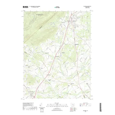
2019 Map of Dillsburg
USGS Topo · Published 2019About this map
Deardorffs Mill and the crossing at Pond Mill Bridge define the agricultural and industrial landscape of this region during the early twenty-first century. This portion of the Cumberland Valley and northern Adams County shows a network of established settlements connected by the Harrisburg Pike, including Dillsburg, York Springs, and Franklintown. The map is particularly useful for genealogical research, documenting numerous burial sites such as the Latimore Mennonite Meetinghouse Cem, Lobach - Bushey Cem, and Sunny Side Cem.
Find a feature on this map
165 named features on this map. Tap any name to fly to it.
Don’t see what you’re looking for? This feature index may not catch every label — zoom into the map to look around manually.
Map Details
Editions of this 2019 Dillsburg Map
This is the sole edition of this map. No revisions or reprints were ever made.
Other maps of this area

1904 · Carlisle
USGS Topo · 1:62,500

1906 · New Cumberland
USGS Topo · 1:62,500

1908 · Gettysburg
USGS Topo · 1:62,500

1920 · Hanover
USGS Topo · 1:62,500

1922 · Hanover
USGS Topo · 1:62,500

1942 · Gettysburg
USGS Topo · 1:125,000

1943 · New Cumberland
USGS Topo · 1:62,500

1943 · Carlisle
USGS Topo · 1:62,500
1944 · Biglerville
USGS Topo · 1:31,680

1944 · Hampton
USGS Topo · 1:31,680