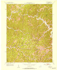
1951 Map of Dingus
USGS Topo · Published 1953About this map
Crockett and Moon serve as primary points of settlement in this dissected plateau landscape along the borders of Morgan, Elliott, and Lawrence counties. The early 1950s terrain is marked by a high density of rural institutions, particularly small schools such as Jeptha Sch, Smith Cr Sch, and Silverhill Sch, which reflect the localized social structure of these hollows before later consolidation. The drainage network, dominated by Paint Creek and the Open Fork Paint Creek, dictates the placement of winding roads and homesteads.
Find a feature on this map
69 named features on this map. Tap any name to fly to it.
Don’t see what you’re looking for? This feature index may not catch every label — zoom into the map to look around manually.
Map Details
Editions of this 1951 Dingus Map
This is the sole edition of this map. No revisions or reprints were ever made.
Other maps of this area

1886 · Prestonsburg
USGS Topo · 1:125,000

1889 · Salyersville
USGS Topo · 1:125,000

1891 · Salyersville
USGS Topo · 1:125,000

1892 · Prestonsburg
USGS Topo · 1:125,000

1899 · Salyersville
USGS Topo · 1:125,000

1903 · Kenova
USGS Topo · 1:125,000

1904 · Kenova
USGS Topo · 1:125,000

1915 · Paintsville
USGS Topo · 1:48,000

1917 · Paintsville
USGS Topo · 1:62,500

1950 · Isonville
USGS Topo · 1:24,000