
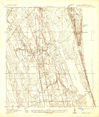
1943 Map of Dinner Island
USGS Topo · Published 1957About this map
The low-lying wetlands of Big Fish Tail Swamp and the Florida Game Refuge dominate this wartime landscape on the border of St. Johns and Flagler Counties. The area is characterized by numerous dry "islands" rising out of the swampy terrain, including Turkey Island, Pine Island, and the eponymous Dinner Island. Transportation corridors provide the primary structural elements of the map, with the Florida East Coast railway and the Old Dixie Highway cutting through the center. Small settlements and sidings like Spuds, Byrd, and Espanola dot the rail lines, while Old Kings Road traces an older path toward Pellicer Creek. The map reflects a period before modern drainage and development transformed this section of the Florida interior, preserving the location of early rural infrastructure like Neoga Sta and the landing at Cedar Landing.
Find a feature on this map
32 named features on this map. Tap any name to fly to it.
Don’t see what you’re looking for? This feature index may not catch every label — zoom into the map to look around manually.
Map Details
Editions of this 1943 Dinner Island Map
This is the sole edition of this map. No revisions or reprints were ever made.
Other maps of this area

1912 · Palatka
USGS Topo · 1:48,000

1915 · Palatka
USGS Topo · 1:62,500

1927 · Matanzas
USGS Topo · 1:48,000

1937 · Elkton
USGS Topo · 1:24,000
1937 · Crescent Beach
USGS Topo · 1:24,000

1937 · Dinner Island
USGS Topo · 1:48,000

1937 · Ormond
USGS Topo · 1:48,000
1943 · St. Augustine
USGS Topo · 1:62,500

1943 · Matanzas
USGS Topo · 1:62,500

1944 · Ormond
USGS Topo · 1:62,500