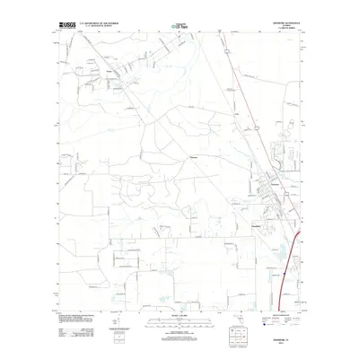
2012 Map of Dinsmore
USGS Topo · Published 2012About this map
Trout River and its tributaries define this landscape on the northwestern outskirts of Jacksonville as it appeared in the early 21st century. The map documents a transition from rural homesteads and named family cemeteries, such as Keen Cem near Keene, to the suburban expansion of Dinsmore and Spaulding. The hydrology of the area is detailed through the courses of Little Trout River, Thomas Cr, and Ninemile Cr, which historically shaped the settlement patterns of these small communities. Significant landmarks from the era, including the Dinsmore Lookout Tower, stand as nautical or forestry markers in a region marked by extensive local road networks like Old Kings Rd. This record provides a clear view of the Corporate Limit 1975, capturing the spatial organization of these Florida neighborhoods before further modern development.
Find a feature on this map
112 named features on this map. Tap any name to fly to it.
Don’t see what you’re looking for? This feature index may not catch every label — zoom into the map to look around manually.
Map Details
Editions of this 2012 Dinsmore Map
This is the sole edition of this map. No revisions or reprints were ever made.
Other maps of this area

1917 · Cambon
USGS Topo · 1:62,500

1917 · Hilliard
USGS Topo · 1:62,500

1918 · St Marys
USGS Topo · 1:62,500

1918 · Cambon
USGS Topo · 1:62,500

1918 · Jacksonville
USGS Topo · 1:62,500

1919 · St Marys
USGS Topo · 1:62,500

1919 · Hilliard
USGS Topo · 1:62,500

1948 · Jacksonville
USGS Topo · 1:250,000

1950 · Trout River
USGS Topo · 1:24,000
1950 · Jacksonville
USGS Topo · 1:24,000