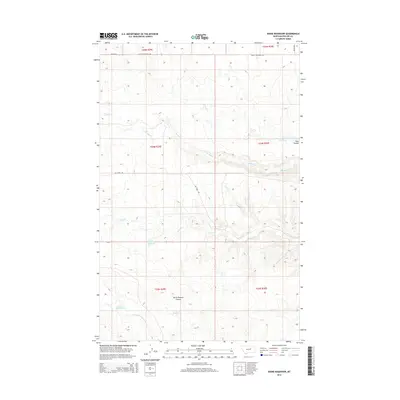
2014 Map of Dione Reservoir
USGS Topo · Published 2014About this map
Dione Reservoir and a series of smaller catchment basins define this arid stretch of Phillips County, where the management of water dominates the landscape. The geography is marked by seasonal drainages including Second Creek, Third Creek, and the North Fork Fourchette Creek, which carve subtle paths through the terrain. Evidence of ranching and land use is clear in the naming of local landmarks like Horse Pasture Coulee and Tank Coulee. This 2014 survey illustrates the sparse network of rural transit, anchored by the Blunt Cutacross Road and Dry Fork Road. The placement of Archie Reservoir, Carberry Reservoir, and Garter Reservoir suggests a highly organized approach to livestock watering and resource preservation in a region where every stream and coulee is named and utilized.
Find a feature on this map
19 named features on this map. Tap any name to fly to it.
Don’t see what you’re looking for? This feature index may not catch every label — zoom into the map to look around manually.
Map Details
Editions of this 2014 Dione Reservoir Map
This is the sole edition of this map. No revisions or reprints were ever made.
Other maps of this area

1954 · Jordan
USGS Topo · 1:250,000

1954 · Lewistown
USGS Topo · 1:250,000

1956 · Jordan
USGS Topo · 1:250,000

1958 · Jordan
USGS Topo · 1:250,000

1959 · Lewistown
USGS Topo · 1:250,000

1964 · Jordan
USGS Topo · 1:250,000

1965 · Karsten Coulee
USGS Topo · 1:24,000

1965 · Whitcomb Lake
USGS Topo · 1:24,000
1965 · Stratton Reservoir
USGS Topo · 1:24,000
1965 · Holzhey Reservoir
USGS Topo · 1:24,000