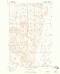
1965 Map of Stratton Reservoir
USGS Topo · Published 1969About this map
First Creek Community Center serves as a lone social anchor in this 1965 survey of the northern Missouri River Basin plains. The landscape is defined by the extensive management of water through a network of catchments and basins including Skull Reservoir, King Reservoir, and Salene Reservoir. These features, along with the First Creek Reservoir and its spillway, illustrate the engineering efforts required to sustain ranching and agriculture across the Sun Prairie Flats.
Find a feature on this map
18 named features on this map. Tap any name to fly to it.
Don’t see what you’re looking for? This feature index may not catch every label — zoom into the map to look around manually.
Map Details
Editions of this 1965 Stratton Reservoir Map
2 editions found
Other maps of this area

1954 · Jordan
USGS Topo · 1:250,000

1956 · Jordan
USGS Topo · 1:250,000

1958 · Jordan
USGS Topo · 1:250,000

1964 · Jordan
USGS Topo · 1:250,000

1965 · Sun Prairie
USGS Topo · 1:24,000

1965 · Herman Point
USGS Topo · 1:24,000

1965 · Whitcomb Lake
USGS Topo · 1:24,000
1965 · Dione Reservoir
USGS Topo · 1:24,000

1965 · Sheep Coulee
USGS Topo · 1:24,000
1965 · Pea Ridge
USGS Topo · 1:24,000