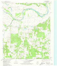
1980 Map of Direct
USGS Topo · Published 1981About this map
The Red River marks the winding border between Oklahoma and Texas, defining the geography of this survey. On the Texas side, the landscape is characterized by the dispersed rural settlements of Direct, Georgia, and Unity, where the Caddo National Grassland preserves large tracts of prairie and timber. This area south of the river is punctuated by family-named landmarks and essential community anchors such as Pyles Cem and the Church of Christ.
Find a feature on this map
24 named features on this map. Tap any name to fly to it.
Don’t see what you’re looking for? This feature index may not catch every label — zoom into the map to look around manually.
Map Details
Editions of this 1980 Direct Map
This is the sole edition of this map. No revisions or reprints were ever made.
Other maps of this area

1903 · Paris
USGS Topo · 1:125,000

1947 · Honey Grove
USGS Topo · 1:62,500

1948 · Grant
USGS Topo · 1:62,500

1948 · Paris
USGS Topo · 1:62,500

1948 · Direct
USGS Topo · 1:62,500

1949 · Direct
USGS Topo · 1:62,500

1949 · Honey Grove
USGS Topo · 1:62,500

1949 · Grant
USGS Topo · 1:62,500

1949 · Paris
USGS Topo · 1:62,500

1953 · Texarkana
USGS Topo · 1:250,000