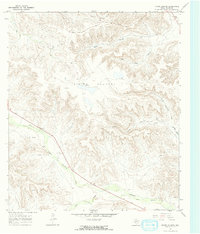
1967 Map of Divide Country
USGS Topo · Published 1970About this map
Yates Field dominates the northwest portion of this West Texas landscape, signifying the intense petroleum extraction activity occurring within the high Divide Country during the late 1960s. The terrain is defined by a series of significant drainage systems, notably Upper Fourmile Draw and Lower Fourmile Draw which cut across the southwestern quadrant, while North Sixmile Draw and its southern counterpart carve through the eastern hills.
Find a feature on this map
16 named features on this map. Tap any name to fly to it.
Don’t see what you’re looking for? This feature index may not catch every label — zoom into the map to look around manually.
Map Details
Editions of this 1967 Divide Country Map
2 editions found
Other maps of this area

1929 · Sheffield
USGS Topo · 1:125,000

1929 · Independence Draw Quadrangle
USGS Topo · 1:125,000

1954 · Fort Stockton
USGS Topo · 1:250,000

1954 · Sonora
USGS Topo · 1:250,000

1958 · Sonora
USGS Topo · 1:250,000

1958 · Fort Stockton
USGS Topo · 1:250,000

1967 · Twelvemile Camp
USGS Topo · 1:24,000

1967 · Divide Country
USGS Topo · 1:24,000

1967 · Sheffield NW
USGS Topo · 1:24,000

1967 · Deer Canyon
USGS Topo · 1:24,000