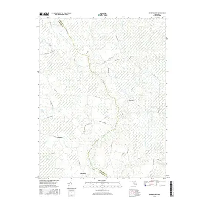
2016 Map of Dividing Creek
USGS Topo · Published 2016About this map
Dividing Creek snakes through the low-lying wetlands of the Lower Eastern Shore, marking the serpentine boundary between Worcester and Somerset counties. This landscape is defined by its water-bound geography, where small settlements like Whiteburg, Cokesbury, Wellington, and Oakville are connected by a network of rural roads traversing significant marshes such as Peggy Boston Swamp and Dublin Swamp. The map reveals a high density of rural burial grounds, including Pusey Cem, Olivet Cem, and Nazareth Cem, which serve as vital markers for local family history in this sparsely populated region. Numerous tributaries, such as Tonys Cr and Cottingham Mill Run, drain into the main creek, illustrating the drainage patterns essential to the area's agricultural and timber-dependent history. The presence of Perryhawkin Cem and Emanuel Cem further underscores the deep-rooted community ties along the woodland edges and creek bends.
Find a feature on this map
53 named features on this map. Tap any name to fly to it.
Don’t see what you’re looking for? This feature index may not catch every label — zoom into the map to look around manually.
Map Details
Editions of this 2016 Dividing Creek Map
This is the sole edition of this map. No revisions or reprints were ever made.
Other maps of this area

1901 · Snow Hill
USGS Topo · 1:62,500

1901 · Salisbury
USGS Topo · 1:62,500

1902 · Pittsville
USGS Topo · 1:62,500

1942 · Kingston
USGS Topo · 1:24,000

1942 · Princess Anne
USGS Topo · 1:24,000

1942 · Snow Hill
USGS Topo · 1:24,000

1942 · Eden
USGS Topo · 1:24,000

1942 · Wango
USGS Topo · 1:24,000

1942 · Dividing Creek
USGS Topo · 1:24,000

1942 · Salisbury
USGS Topo · 1:24,000