
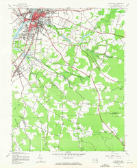
1942 Map of Salisbury
USGS Topo · Published 1962About this map
The confluence of the Wicomico River and its varied branches forms the heart of this mid-century look at the Eastern Shore. In Salisbury, the convergence of the Pennsylvania RR and the Baltimore and Eastern RR anchors a growing town center, while institutions like the Wicomico Orphanage and Wicomico Memorial Park provide social landmarks for the era. The map traces the transition from the concentrated urban street grid to rural landscapes south toward Fruitland and east toward Mt Hermon.
Find a feature on this map
40 named features on this map. Tap any name to fly to it.
Don’t see what you’re looking for? This feature index may not catch every label — zoom into the map to look around manually.
Map Details
Editions of this 1942 Salisbury Map
2 editions found
Other maps of this area

1901 · Snow Hill
USGS Topo · 1:62,500

1901 · Salisbury
USGS Topo · 1:62,500

1902 · Pittsville
USGS Topo · 1:62,500

1942 · Princess Anne
USGS Topo · 1:24,000

1942 · Snow Hill
USGS Topo · 1:24,000

1942 · Eden
USGS Topo · 1:24,000

1942 · Wango
USGS Topo · 1:24,000

1942 · Hebron
USGS Topo · 1:24,000

1942 · Dividing Creek
USGS Topo · 1:24,000

1942 · Delmar
USGS Topo · 1:24,000