
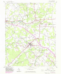
1942 Map of Hebron
USGS Topo · Published 1962About this map
Hebron serves as a central hub in this early 1940s landscape, situated at a critical junction where road networks and the Baltimore and Eastern railroad intersect. The map illustrates a rural economy deeply tied to the local hydrology of the Wicomico and Sussex county borderlands. Tributaries like Barren Creek, Rewastico Creek, and Quantico Creek snake through the terrain, supporting local landmarks such as Mockingbird Pond and Rewastico Pond.
Find a feature on this map
22 named features on this map. Tap any name to fly to it.
Don’t see what you’re looking for? This feature index may not catch every label — zoom into the map to look around manually.
Map Details
Editions of this 1942 Hebron Map
2 editions found
Other maps of this area

1901 · Salisbury
USGS Topo · 1:62,500

1903 · Nanticoke
USGS Topo · 1:62,500

1905 · Hurlock
USGS Topo · 1:62,500

1915 · Seaford
USGS Topo · 1:62,500

1942 · Wetipquin
USGS Topo · 1:24,000

1942 · Mardela Springs
USGS Topo · 1:24,000

1942 · Eden
USGS Topo · 1:24,000

1942 · Salisbury
USGS Topo · 1:24,000

1942 · Delmar
USGS Topo · 1:24,000
1943 · Mardela Springs
USGS Topo · 1:31,680