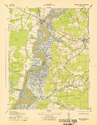
1943 Map of Mardela Springs
USGS Topo · Published 1943About this map
The Nanticoke River carves a deep, winding path through the heart of the Eastern Shore, defining the border between Dorchester and Wicomico counties. At the head of this reach, Vienna serves as a critical crossing point, marked by an East Tower and West Tower flanking the bridge. The surrounding landscape is a complex network of marshlands and tidal guts, including the extensive Beaverdam Swamp and Sageberry Swamp. Small rural hubs like Mardela Springs and Rabbit Town are connected by a web of early roads and crossroads, such as Hollands Crossroads and Henrys Crossroads. The map reveals the river-dependent economy of the 1940s, noting riverfront infrastructure like Camphels Whf and specialized landmarks like the Top Brick Silo, which provide valuable touchpoints for tracing family homesteads and local maritime history.
Find a feature on this map
69 named features on this map. Tap any name to fly to it.
Don’t see what you’re looking for? This feature index may not catch every label — zoom into the map to look around manually.
Map Details
Editions of this 1943 Mardela Springs Map
This is the sole edition of this map. No revisions or reprints were ever made.
Other maps of this area

1901 · Salisbury
USGS Topo · 1:62,500

1903 · Nanticoke
USGS Topo · 1:62,500

1905 · Hurlock
USGS Topo · 1:62,500

1915 · Seaford
USGS Topo · 1:62,500

1942 · Wetipquin
USGS Topo · 1:24,000

1942 · Mardela Springs
USGS Topo · 1:24,000

1942 · Eden
USGS Topo · 1:24,000

1942 · Hebron
USGS Topo · 1:24,000
1942 · Nanticoke
USGS Topo · 1:24,000
1942 · Chicamacomico
USGS Topo · 1:24,000