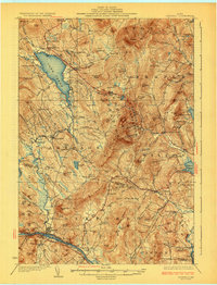
1929 Map of Dixfield
USGS Topo · Published 1929About this map
Lake Webb and the surrounding peaks of the Washington Plantation region dominate this late-1920s topography, illustrating a landscape where rural industry and education were deeply decentralized. The map shows a high density of neighborhood schools, such as Science Hill Sch, Staples Sch, and Jay Interval Sch, reflecting the small, localized communities scattered through the hills. Industry is represented by Mildreths Mill near Hills Pond, while the Maine Central RR provides a critical transportation corridor along the southern edge through the town of Dixfield.
Find a feature on this map
146 named features on this map. Tap any name to fly to it.
Don’t see what you’re looking for? This feature index may not catch every label — zoom into the map to look around manually.
Map Details
Editions of this 1929 Dixfield Map
5 editions found

Other maps of this area

1910 · Livermore
USGS Topo · 1:62,500

1911 · Bryant Pond
USGS Topo · 1:62,500

1911 · Buckfield
USGS Topo · 1:62,500

1912 · Livermore
USGS Topo · 1:62,500

1913 · Buckfield
USGS Topo · 1:62,500

1914 · Bryant Pond
USGS Topo · 1:62,500

1924 · Farmington
USGS Topo · 1:62,500

1926 · Dixfield
USGS Topo · 1:62,500

1927 · Rumford
USGS Topo · 1:48,000

1929 · Phillips
USGS Topo · 1:48,000