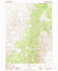
1990 Map of Dixie Hot Springs NE
USGS Topo · Published 1990About this map
The Stillwater Range dominates this Churchill County landscape, rising sharply from the floor of Dixie Valley to the east. This 1990 provisional survey captures a high-desert environment defined by resource extraction and sparse ranching outposts. Anderson Ranch serves as a primary human landmark amidst a complex drainage network that includes Hughes Canyon and White Rock Canyon. The terrain shows significant evidence of mineral exploration, with an Open Pit Mine and various prospect locations indicating the area's geological value. Access to these higher elevations is documented via a traditional Pack Trail and other unimproved routes, reflecting the region's isolated character. Further south, Iron Hat Canyon and Copper Kettle Canyon cut through the western slopes, illustrating the dramatic erosion patterns common to this part of Nevada.
Find a feature on this map
11 named features on this map. Tap any name to fly to it.
Don’t see what you’re looking for? This feature index may not catch every label — zoom into the map to look around manually.
Map Details
Editions of this 1990 Dixie Hot Springs NE Map
This is the sole edition of this map. No revisions or reprints were ever made.
Other maps of this area

1908 · Carson Sink
USGS Topo · 1:250,000

1910 · Carson Sink
USGS Topo · 1:250,000

1931 · Lovelock
USGS Topo · 1:250,000

1932 · Sonoma Range
USGS Topo · 1:250,000

1935 · Lovelock
USGS Topo · 1:250,000

1939 · Sonoma Range
USGS Topo · 1:250,000

1954 · Buffalo Mtn
USGS Topo · 1:62,500

1955 · Millett
USGS Topo · 1:250,000

1955 · Lovelock
USGS Topo · 1:250,000

1955 · Winnemucca
USGS Topo · 1:250,000