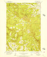
1953 Map of Dixie Mountain
USGS Topo · Published 1956About this map
Dixie Mtn rises at the intersection of Washington, Multnomah, and Columbia counties, anchoring a 1950s landscape defined by ridge-top ranching and remote mountain schools. The region is marked by its educational history, featuring several rural campuses including Wallace Sch and Shadybrook School, as well as sites like Canyon Sch (Aban'd) and Mason Hill Sch (Aban'd) that were already recorded as abandoned by this era.
Find a feature on this map
50 named features on this map. Tap any name to fly to it.
Don’t see what you’re looking for? This feature index may not catch every label — zoom into the map to look around manually.
Map Details
Editions of this 1953 Dixie Mountain Map
This is the sole edition of this map. No revisions or reprints were ever made.
Other maps of this area

1915 · Hillsboro
USGS Topo · 1:62,500

1918 · Hillsboro
USGS Topo · 1:62,500

1922 · St. Helens
USGS Topo · 1:62,500

1940 · Hillsboro
USGS Topo · 1:62,500

1940 · Vernonia
USGS Topo · 1:62,500

1941 · St Helens
USGS Topo · 1:62,500

1941 · Gales Creek
USGS Topo · 1:62,500

1943 · Vernonia
USGS Topo · 1:62,500

1943 · St Helens
USGS Topo · 1:62,500

1948 · Vancouver
USGS Topo · 1:250,000