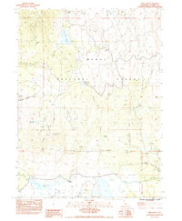
1983 Map of Dixie Peak
USGS Topo · Published 1983About this map
Dixie Valley anchors this high-elevation landscape in the early 1980s, where seasonal ranching and water management define the high desert terrain. The presence of Dixie Ranch and the Dixie Crossing at Indian Creek suggest a long-standing reliance on the valley's drainage systems. The map details a network of reservoirs and springs, such as Wagontire Reservoir and Hoover Flat Reservoir, which were essential for managing livestock and land health within the Modoc National Forest.
Find a feature on this map
41 named features on this map. Tap any name to fly to it.
Don’t see what you’re looking for? This feature index may not catch every label — zoom into the map to look around manually.
Map Details
Editions of this 1983 Dixie Peak Map
2 editions found
Other maps of this area

1886 · Alturas
USGS Topo · 1:250,000

1886 · Honey Lake
USGS Topo · 1:250,000

1886 · Lassen Peak
USGS Topo · 1:250,000

1886 · Modoc Lava Bed
USGS Topo · 1:250,000

1891 · Honey Lake
USGS Topo · 1:250,000

1892 · Modoc Lava-Bed
USGS Topo · 1:250,000

1892 · Lassen Peak
USGS Topo · 1:250,000

1892 · Alturas
USGS Topo · 1:250,000

1893 · Honey Lake
USGS Topo · 1:250,000

1894 · Lassen Peak
USGS Topo · 1:250,000