
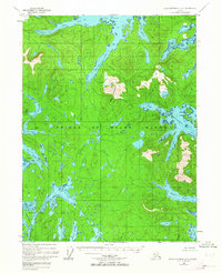
1948 Map of Dixon Entrance D-1
USGS Topo · Published 1957About this map
Prince of Wales Island is depicted here in a series of intricate coastal inlets and high elevations within the Tongass National Forest. The map captures the maritime character of the southern archipelago, anchored by the dominant Bokan Mountain and the deep recesses of Moira Sound. A notable point of human history is the Cannery (Abandoned) located on Hunter Bay, representing the mid-century industrial footprint of the salmon fishing industry that once thrived in these waters.
Find a feature on this map
32 named features on this map. Tap any name to fly to it.
Don’t see what you’re looking for? This feature index may not catch every label — zoom into the map to look around manually.
Map Details
Editions of this 1948 Dixon Entrance D-1 Map
2 editions found
Other maps of this area

1948 · Dixon Entrance D-2
USGS Topo · 1:63,360

1948 · Prince Rupert D-6
USGS Topo · 1:63,360

1948 · Dixon Entrance C-1
USGS Topo · 1:63,360

1948 · Ketchikan A-6
USGS Topo · 1:63,360

1948 · Craig A-1
USGS Topo · 1:63,360

1948 · Craig A-2
USGS Topo · 1:63,360

1951 · Prince Rupert
USGS Topo · 1:250,000

1951 · Dixon Entrance
USGS Topo · 1:250,000

1951 · Dixon Entrance D-2
USGS Topo · 1:63,360

1951 · Craig A-2
USGS Topo · 1:63,360