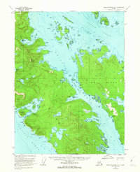
1951 Map of Dixon Entrance D-3
USGS Topo · Published 1963About this map
Howkan (Site) and Koianglas (Site) anchor the historic landscape of this maritime survey, marking significant settlement locations along the intricate waterways of the Alexander Archipelago. Situated on Long Island and the southwestern coast of Prince of Wales Island, the map captures a complex network of channels including Kaigani Strait and Howkan Narrows. The economy and land use of the mid-twentieth century are evidenced by a Cannery at Rose Inlet and various cabins scattered along the shoreline.
Find a feature on this map
65 named features on this map. Tap any name to fly to it.
Don’t see what you’re looking for? This feature index may not catch every label — zoom into the map to look around manually.
Map Details
Editions of this 1951 Dixon Entrance D-3 Map
2 editions found
Other maps of this area

1948 · Craig A-4
USGS Topo · 1:63,360

1948 · Dixon Entrance D-2
USGS Topo · 1:63,360
1948 · Dixon Entrance C-3
USGS Topo · 1:63,360

1948 · Dixon Entrance D-4
USGS Topo · 1:63,360

1948 · Dixon Entrance D-3
USGS Topo · 1:63,360

1948 · Craig A-3
USGS Topo · 1:63,360

1948 · Craig A-2
USGS Topo · 1:63,360

1951 · Dixon Entrance
USGS Topo · 1:250,000

1951 · Dixon Entrance D-3
USGS Topo · 1:63,360

1951 · Dixon Entrance D-2
USGS Topo · 1:63,360