Loading...
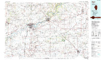
Loading map...1985 Map of Dixon
USGS Topo · Published 1989About this map
The Rock River winds through northwestern Illinois, anchoring a landscape where industrial centers like Dixon and Sterling meet the vast agricultural plains of the 1980s. This regional survey captures the intersection of major transportation corridors, notably the East-West Tollway and a dense network of rail lines including the Chicago and North Western and Burlington Northern. In Dixon, the Charles R Walgreen Field and the State Developmental Center stand as significant landmarks.
Find a feature on this map
165 named features on this map. Tap any name to fly to it.
Don’t see what you’re looking for? This feature index may not catch every label — zoom into the map to look around manually.
Map Details
Date Portrayed1985
Date Published1989
PublisherU.S. Geological Survey
Map TypeTopographic
Scale1:100,000
Physical Dimensions40 x 24.1 inches
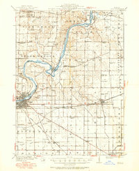
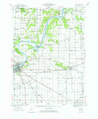
Editions of this 1985 Dixon Map
2 editions found

Historical Maps of Dixon Through Time
Featured Locations
Source Details
SourceU.S. Geological Survey
CopyrightPublic Domain