
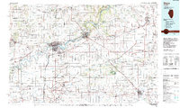
1985 Map of Dixon
USGS Topo · Published 1985About this map
The Rock River corridor anchors this mid-1980s landscape, winding through industrial and educational hubs like Dixon, Sterling, and Rock Falls. Between these population centers, the terrain is characterized by a dense network of private airfields and agricultural infrastructure, including the Charles R Walgreen Field and numerous family-named landing strips such as the Hardesty Landing Strip and Sword Landing Strip. The region's commitment to conservation is evident in large tracts like the Green River State Wildlife Management Area and White Pines Forest State Park.
Find a feature on this map
186 named features on this map. Tap any name to fly to it.
Don’t see what you’re looking for? This feature index may not catch every label — zoom into the map to look around manually.
Map Details
Editions of this 1985 Dixon Map
2 editions found
Other maps of this area

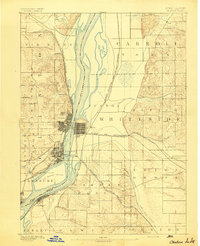
1891 · Clinton
USGS Topo · 1:62,500

1892 · Savanna
USGS Topo · 1:62,500

1892 · Ottawa
USGS Topo · 1:62,500

1893 · Hennepin
USGS Topo · 1:62,500

1893 · Lasalle
USGS Topo · 1:62,500
1894 · Clinton
USGS Topo · 1:62,500

1899 · Clinton
USGS Topo · 1:125,000

1909 · Hennepin
USGS Topo · 1:62,500

1911 · La Salle
USGS Topo · 1:62,500

1911 · Hennepin
USGS Topo · 1:62,500