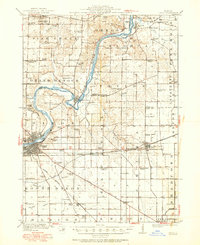
1918 Map of Dixon
USGS Topo · Published 1950About this map
The Rock River creates a dramatic oxbow at Grand Detour, a geographic focal point of this Ogle and Lee County landscape. This mid-century update of earlier 1916 fieldwork shows the area's agricultural and institutional maturity, featuring the sprawling Mil Res and the County Farm near Daysville. The region is defined by a dense network of early 20th-century rural education, including the White Temple School, Harmony Hill School, and Lighthouse School, reflecting the era's decentralized community structure before the widespread consolidation of districts.
Find a feature on this map
85 named features on this map. Tap any name to fly to it.
Don’t see what you’re looking for? This feature index may not catch every label — zoom into the map to look around manually.
Map Details
Editions of this 1918 Dixon Map
3 editions found
Other maps of this area

1917 · Kings
USGS Topo · 1:62,500

1918 · Dixon
USGS Topo · 1:62,500

1918 · Kings
USGS Topo · 1:62,500

1922 · Oregon
USGS Topo · 1:62,500

1924 · Oregon
USGS Topo · 1:62,500

1930 · Woodsung
USGS Topo · 1:48,000

1942 · Forreston
USGS Topo · 1:62,500

1945 · Forreston
USGS Topo · 1:62,500

1946 · Sterling
USGS Topo · 1:62,500

1948 · Sterling
USGS Topo · 1:62,500